History of Cotabato Basin: The Oil and Gas DepoCenter of the Philippines
Abstract
The Agusan-Davao Trough and the Cotabato Basin are the most favorable regions for commercial oil accumulation in Mindanao. They are underlain by thick successions of sedimentary rocks and have many possibilities for structural and stratigraphic traps. The maximum thickness ranges between 12,000 and 15,000 feet in Agusan and between 6,000 and 14,000 feet in Cotabato. An oil seepage in northern Cotabato and oil and gas reported in a shallow hole indicate that petroleum generation occurred in the Cotabato Basin. (RECONNAISSANCE GEOLOGY AND OIL POSSIBILITIES OF MINDANAO’ T. S. M. RANNEFT,^ ROY M. HOPKINS, JR.,’ ALBERT J. FROELICH,’ AND JOHN W. GWINN’ Manila, Philippines. Published as Bulletin of the American Association of Petroleum Geologists Volume 44, Number 5 May 1960).
Introduction
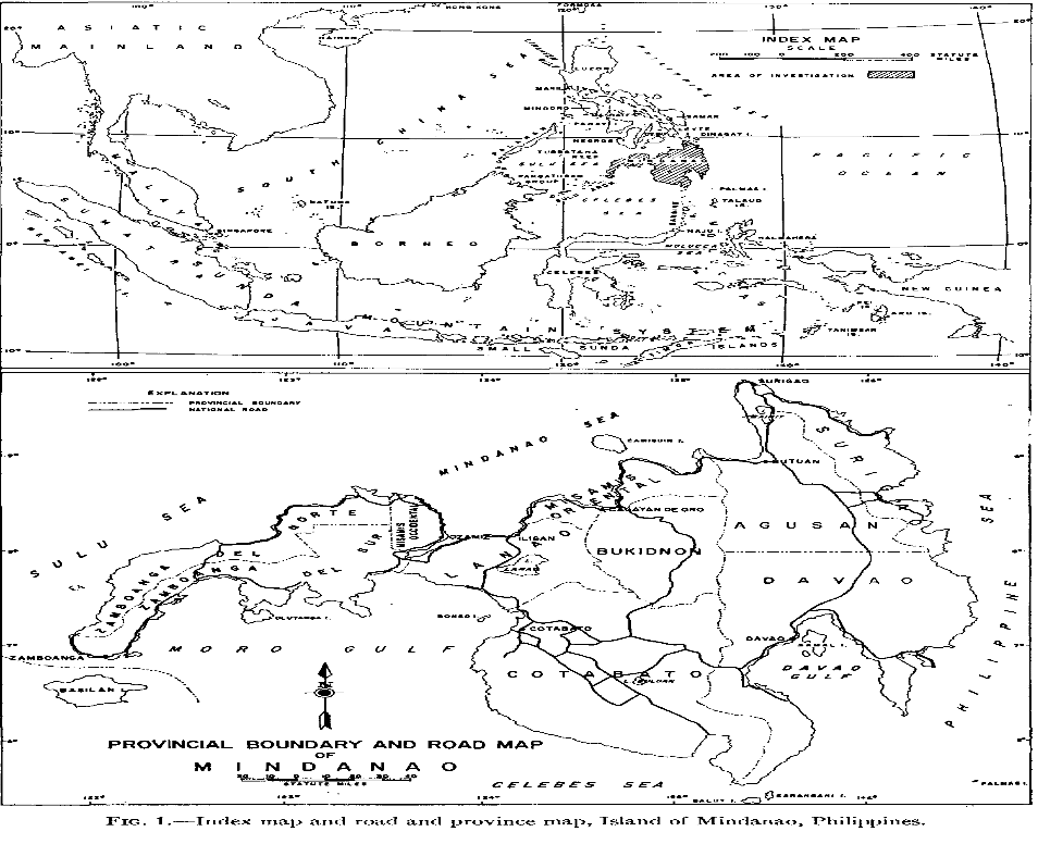
Cotabato Basin is northwest – trending depocenter situated in the Southcentral of Mindanao[1]. It is bounded by the Lanao-Bukidnon Highlands in the north, the Tiruray-Daguma Highlands in the west and southwest, the Apo-Parker Range in the southeast and the Central Cordillera in the east. The total land area of Cotabato Basin is measured at 1.2 million hectares (12,000 square kilometers). The maximum thickness of oil and gas deposit is calculated at 8 kilometers. The Cotabato Basin is considered a back-arc basin, meaning it is connected to a larger basin of East Indonesia. Region wise, Cotabato Basin is situated in the provinces of North and South Cotabato, Maguindanao and Sultan Kudarat.
Noel L Felicia, CEO SK Liguasan Oil and Gas Corporation 06 June 2022
J.L.Buckley, President of San Jose Oil Company, Inc. This company conducted drilling operation in the Roxas Mountain Range, Banga, Cotabato Basin in 1962
T. S. M. Ranneft is the General Manager while Roy M. Hopkins, Jr, Albert J. Froelich and John W. Gwinn are the geologists of San Jose Oil Company, Inc. Manuscript of report completed on 02 November 1959.
The Cotabato Basin, like the Agusan-Davao Trough, appears to be a half-graben. The basin received sediments primarily from the Central Cordillera, and during the times the Tiruray High- land was positive, it also was a source of sediments. The Lanao-Bukidnon volcanic area was a source area after Miocene time. During most of its depositional history, the Cotabato Basin was part of a subsiding north-trending trough, extend- ing from the Mindanao Sea to the Celebes Sea. Located on the continent side of a major orogenic belt (Central Cordillera) it may be described as an idiogeosyncline (Umbgrove, 1947, p. 50). During the times the Tiruray Highland was entirely or partly submerged, the Cotabato Basin may have been part of a single depositional region encompassing the Celebes Sea and the geosynclines of northeast Borneo.
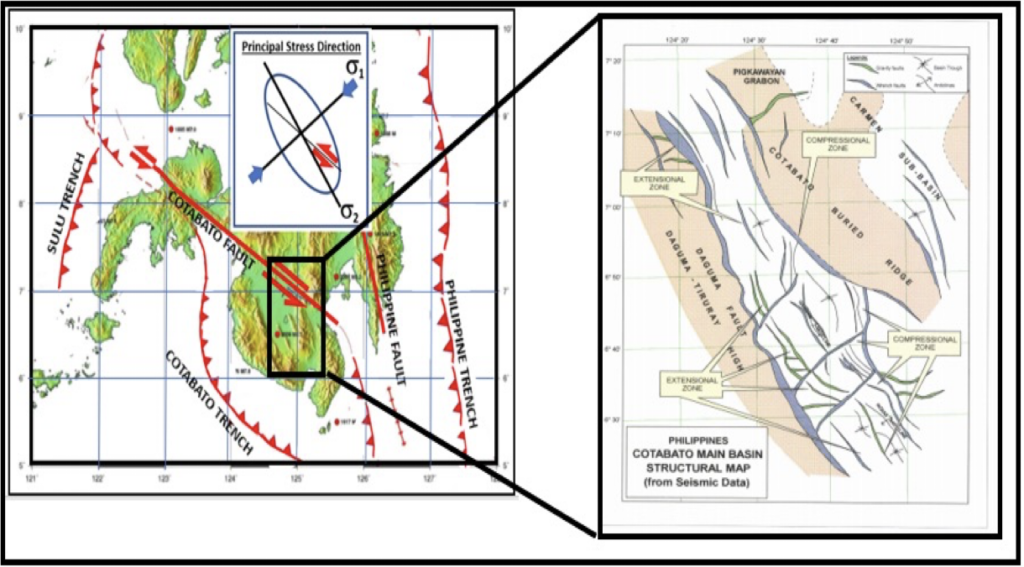
The Cotabato Basin Structural Map
Explanation of Oil Possibilities
The findings that the Cotabato Basin has large amount of commercial deposit of oil and gas are backed-up by the following geological and scientific facts that qualified and classified the area as an oil and gas prospect:
- Potential source and cap rocks.—Abundant fossiliferous marine Miocene and Pliocene shales and mudstones are potential source beds as well as cap rocks. During most of the Tertiary it is probable that the Cotabato Basin and much of the Agusan- Davao Trough were silled basins.
- Potential reservoir rocks.—Limestones are widely distributed stratigraphically and geo- graphically, and they are possible reservoir rocks. Exposures of Eocene limestone are more than 2,000 feet thick in Agusan, and Miocene and Pliocene limestones in both basins range in thickness from 150 to more than 1,500 feet. Numerous Miocene and Pliocene sandstones and conglomerates could serve as reservoirs in the Agusan-Davao Trough and the Cotabato Basin.
- Potential structural traps.—There are several known surface structures in the Cotabato Basin that could serve as traps. The Cotabato Basin contains many surface anticlines and other structures favorable for the entrapment of hydrocarbons. The most attractive major features are the Roxas anticline, the structures along the Cotabato buried ridge, and the Nica-an anticline. The Roxas anticline is the largest and best defined petroleum prospect in the southern Cotabato Basin. It is a closed structure 14 miles long and 4 miles wide and is formed in Miocene, and 4 miles wide and is formed in Miocene, Pliocene, and Pleistocene rocks.
- Potential stratigraphic traps.—The Agusan-Davao Trough and the Cotabato Basin have good possibilities for stratigraphic traps which may become of prime importance after subsurface relations are clarified by exploratory drilling on known structures.
Exploration History
The history of oil and gas exploration in the Philippines actually started in the Cotabato Basin. A total of 12 wells were drilled in the Cotabato Basin between 1916 and 1996[1]. The earliest well drilled was Dulawan-1, which was originally a water well, but instead intersected oil-bearing sands and was able to flow 12 barrels of oil per day. Dulawan-I was drilled in Dulawan (Poblacion), a barangay in Datu Piang, a second-class municipality in the province of Maguindanao in 1916. This was the very first exploratory hole in Mindanao and the well drilled reached a total depth of 1,800 feet and oil and gas shows associated with salt water were obtained from sandstones at 300; 1,400 and 1,800 feet respectively (Healy, 1959).
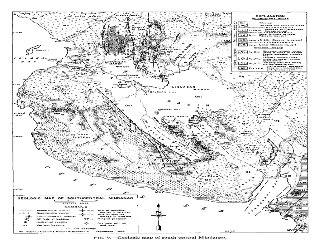
The Geologic Map of Southcentral Mindanao, where the Cotabato Basin is situated was published in September 1959. This is also the same period when American geologists and geo-scientists employed by the Petroleum Geophysical International Corporation, USA conducted Gravity and Seismic Survey in the Cotabato Basin specifically in the municipalities of Lambayong (Gansing, Lagao and Tukanakuden), Isulan (Bambad) and President Quirino (Pedtubo) in the province of Sultan Kudarat. The seismogram, profile sections and seismic data report which were undertaken from 22 August 1959 to 12 April 1960 and from 29 May to 03 July 1960 were interpreted by D. V. Chipera and further revised by C.W. Allen of W.M. Cabeen & Associates in October 1960. The completed seismic report was bought by Maremco Mineral Corporation and Anglo Philippines Oil Corporation and became the basis for them to form a joint venture company called Anglo-Maremco that in 1962 began its oil and gas exploration in Sultan Kudarat.
Noel Lucas, SKLOGC Chief Geologist
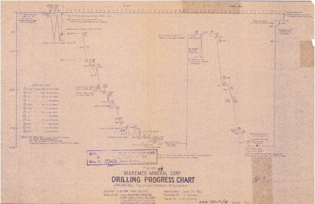
The drilling operation of Anglo-Maremco with its American crew was unsuccessful. The reasons behind were as follows: (1) the Cotabato Basin is categorized a high-pressure zone which the technology in the 1960’s could not address; and (2) the rated drill rig capacity is limited to 6,000 feet which latest prognosis study indicates the rig must breach the minimum depth of 8,250 feet. While the effort of Anglo-Maremco was unsuccessful because of rig difficulty, presence of oil and gas especially in the Gansing sites which flared out to a height of 68 feet for several days cannot be denied any longer. In his Final Report of Gansing 1 & 2 and Bambad 1 wells, which the Chief Geologist Ignacio S Antonio published on 25 November 1964 concluded that the Gansing prospect remains a viable business venture. The oil and gas deposit in Gansing settles in a 5,000-hectare reservoir (one-fourth of the land area of Lambayong, Sultan Kudarat) at a penetrable depth of 8,250 feet and volumetric thickness of 600 meters. Shown below is the Drilling Progress Chart of Anglo-Maremco reported on 24 June 1962. The irregular lines according to our Chief Drill Engineer indicated an intense rig difficulty encountered by the drillers due to the high – pressure zone characteristics of the Gansing site.
The first exploration well Gansing -1 was drilled in 1962 to test a seismically defined anticline. The well however did not reach its target depth due to over-pressuring at Early Pliocene clastic level. Several wells with various targets from sandstone to limestone (carbonate) reservoirs were drilled all over the basin.
The first 240-line kilometers of 2D single fold seismic data was acquired by Maremco in 1962, which was the basis for the assessment and the drilling of Gansing 1 & 2 structural interpretation. Another 381-line kilometers of 6-12 Fold 2D seismic survey was acquired by Fil-Am Resources, which was the basis for the other wells Roxas well, Bambad and Pedtobo.

The 1983 aeromagnetic survey results on the entire Cotabato Basin revealed that the thickness sediments are 6.5 kilometer and 4.5 kilometers near Cotabato city and near Tukanakuden-1 well, near Lambayong area respectively, which tells us that there is high probability of matured source rocks and presence of hydrocarbon (oil and gas) in the basin as shown by the hydrocarbon shows in 5 out of 12 wells drilled. That includes Dulawan-1 wells which intersected oil.
The next most interesting site in the Cotabato Basin is the Roxas Range, found in the mountain between the municipalities of Tantangan and Banga in South Cotabato. It was here that San Jose Oil Company and its operator South Seas Oil Exploration company began its exploration and drilling operation in 1962. They were encouraged by the geological finding that the Roxas anticline is the largest and best defined petroleum prospect in the southern Cotabato Basin. It is a closed structure 14 miles long and 4 miles wide and is formed in Miocene, which the area is measured to be around 15,000 hectares containing 4.8 billion barrels (4.8BBL) of crude oil[2]. The same with Anglo-Maremco, San Jose Oil exploration effort (they drilled 3 wells) was unsuccessful because of the high pressure zone classification of the Roxas Well and the drill rig employed had a limited rated capacity of only 6,000 feet, failing to breach the reservoir determined to be at 8,250 feet.
The Three Roxas wells encountered oil shows, while Gansing and Tukanakuden wells recorded gas shows in multiple levels, basically biogenic gas associated with formation water. Thermal gradient of the basin was established on four wells. It showed a low thermal gradient, however, was compensated by the thick overburden sediments confirmed by gravity, magnetics and seismic data gathered in the entire Cotabato basin.
After their unsuccessful attempt to produce oil and gas in Sultan Kudarat in the 1960’s, a team of Texas Rangers hired by Shell USA landed in Cotabato City in 1980 to pursue their unfinished business in Gansing. Unfortunately, they were prevented by some powerful personalities to proceed and were told to return to America. This same team went to Palawan in 1990 and had a Joint Operating Agreement with Occidental Petroleum USA. Oxy owned the Malampaya-Camago Offshore Service Contract 38. After 2 years, Shell bought the shares of Oxy Petroleum and took 6 years to produce commercial quantity of natural gas. In October 2000, 3.2 TCF of natural gas from the Malampaya gasfield was connected to the Shell Tabangao facility in Batangas via a 504 – kilometer gas pipeline and supplied 3 power plants to generate 3,200 MW of electrical power to the Luzon grid. The Malampaya reservoir is diminishing and could be exhausted in 2025 which by that time the Sultan Kudarat gas could take over as the main source of natural gas in the Philippines.
The Roxas Well formerly belongs to Area 09 of the so-called Petroleum Conventional Energy Contracting Program (PCECP) and is now part of the 72,000-hectare Petroleum Service Contract 77. The oil deposit could be seen in the black ink in the above Geologic Map of Roxas Range.
In the mid 1980’s up to 1997, the Philippine National Oil Company (PNOC) and its exploration arm PNOC-EC partnered with Petronas Carigali Overseas Sdn Bhd. (PCSOB) of Malaysia and Petrofields to conduct further exploration in the Cotabato Basin. Of the 12 wells drilled in the Cotabato Basin, only 5 (five) wells have valid tests results namely, Pedtobo-1 (PTB-1), Roxas-1 (RXS-1), Roxas-2(RXS-2) and Roxas-3(RXS-3) and Tukanakuden-1 (TKN-1) or Sultan sa Barongis wells. These wells were plugged and abandoned. Tests results encountered high methane gas (C1) at the following depth interval; 270-330 ft, 1,555-1,800 feet, 2103-2235 feet. RFT gas sample confirmed to be C1 gas from sandstone beds.
Sultan Sa Barongis (SSB-1) was plug and abandoned. The well was tested at depth yielded stabilized natural gas flow rate of 186,000 standard cubic feet of gas per day. Sultan Sa Barongis-2 (SSB-2) was plugged and abandoned. The well was tested at depth flowed and measured a flow rate of 270,000 standard cubic feet of gas per day (SCFPD) SCFPD.
A renewed interest in the Cotabato Basin exploration was initiated by the Canadian Government and sponsored the first 30 -Fold 2D seismic acquired in 1993 for a total of 586 line kilometers of seismic data and followed by another 208 line kilometers of 40 fold 2D seismic data that was completed in 1996. These seismic data confirmed the presence of four (4) structural traps, 10 stratigraphic traps and 4 combination traps.
The 1996 aerogravity and magnetics survey which comprised of 2,120-line kilometers of 3 kms grid increment were acquired by Carson Services Inc. of USA[1], also revealed three major ramp features with build-up features were spotted along Pigkawayan-Midsayap, Muntod-Taviran and Sharif-Aguak gravity highs[2].
The Cotabato Basin is considered “Unfinished Business” to the Americans.
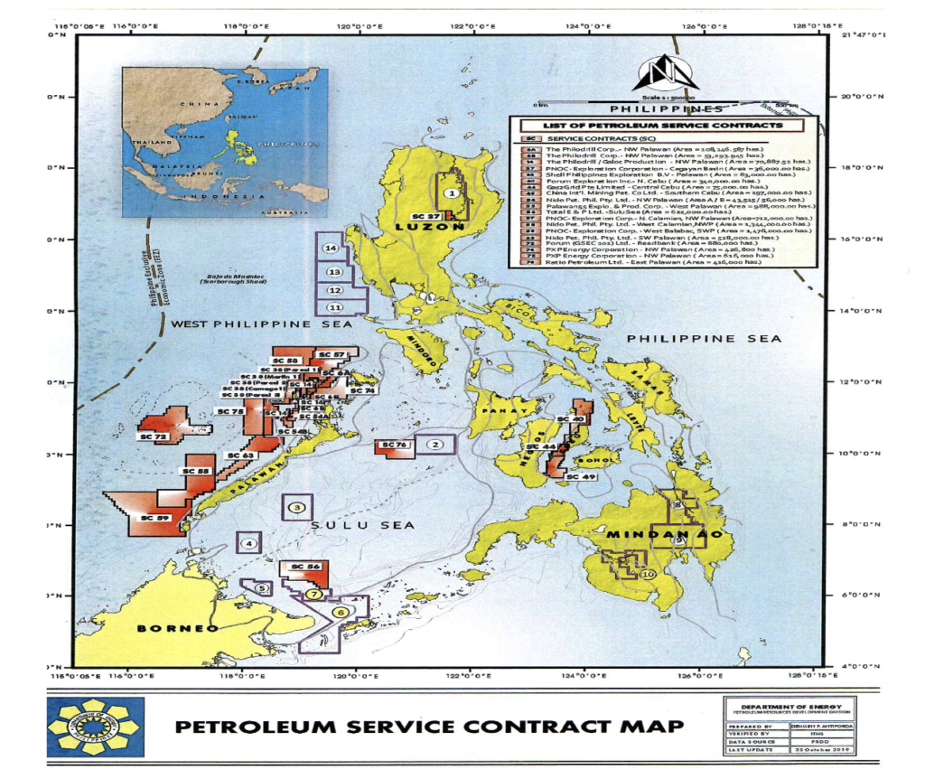
In 1997, there was a serious security incident that happened in Sultan sa Barongis that prompted the PNOC and the Department of Energy (DOE) to stop further exploration in the area. As can be seen in the above Petroleum Service Contract Map while the rest of the country have exploration areas (ones in red) Mindanao has none.
The Cotabato Basin is considered “Unfinished Business” to the Americans.
In 1997, there was a serious security incident that happened in Sultan sa Barongis that prompted the PNOC and the Department of Energy (DOE) to stop further exploration in the area. As can be seen in the above Petroleum Service Contract Map while the rest of the country have exploration areas (ones in red) Mindanao has none.
Resumption Act
For more than 2 decades, the Cotabato Basin was considered a “No Man’s Land” to oil and gas exploration. Things began to turn around when Mayor Rodrigo Roa Duterte[1] (PRRD) of Davao City, was elected as President of the Republic of the Philippines in 2016. In the oil and gas industry of the Philippines, PRRD made 3 significant contributions which impacted the resumption of petroleum activities in the Cotabato Basin which are as follows:
- PRRD signed Republic Act (RA) No. 11054 otherwise known as Bangsamoro Basic Law[2] (BBL) “An Act to strengthen and expand the Organic Act for the Autonomous Region in Muslim Mindanao” on 26 July 2018.
- In October 2019 while on a state visit to Russia, PRRD gave specific instruction to then Governor Suharto “Teng” Mangudadatu, Ph.D. of Sultan Kudarat to drill already the oil and gas deposit in his province to include Liguasan Marsh[3].
- On 12 January 2022, PRRD issued a Presidential Memorandum directing the Department of Energy to sign and award the Petroleum Service Contract (PSC) 77 to SK Liguasan Oil and Gas Corporation (SKLOGC), an all Filipino Mindanao-based company. The final signing of the PSC
First Philippine President from Mindanao
RA no. 11054 created the new Bangsamoro Autonomous Region in Muslim Mindanao (BARMM). Major parts of the Cotabato Basin are inside BARMM like the whole province of Maguindanao including the uncharted and unexplored Liguasan Marsh and some barangays in the municipality of Midsayap, North Cotabato that indicated oil shows in the past. The effect of the creation of the new BARMM relieved the country from the security issues and stress started by the founders of the Mindanao Independence Movement (MIM) and the Moro Islamic Liberation Forces (MILF) led by the late Chairman Hashim Salamat who hailed from Barangay Cudal, Pagalungan, Maguindanao. The new BARMM ushered the entry of peace and development and resumption of oil and gas exploration in the Cotabato Basin.
This instruction of PRRD reflected the appreciation of a sitting President on the vast potential of the oil and gas reservoir of the Cotabato Basin, the impact of which could be considered as one of his legacies to the Filipino people.

Petroleum Service Contract 77
Under the PCECP, the Cotabato Basin is divided into 2 areas: Area 09 and Area 10. Area 09 is inside the provinces of Sultan Kudarat and South Cotabato (Region XII) while Area 10 is inside BARMM. Area 09 is subject to the jurisdiction and regulation of DOE while Area 10 is controlled by BARMM. On 03 November 2020, the DOE conducted a bidding for Area 09 which was eventually won by SKLOGC. On 07 April 2022, the Petroleum Service Contract 77 was signed by Energy Secretary Alfonso Cusi and this author.
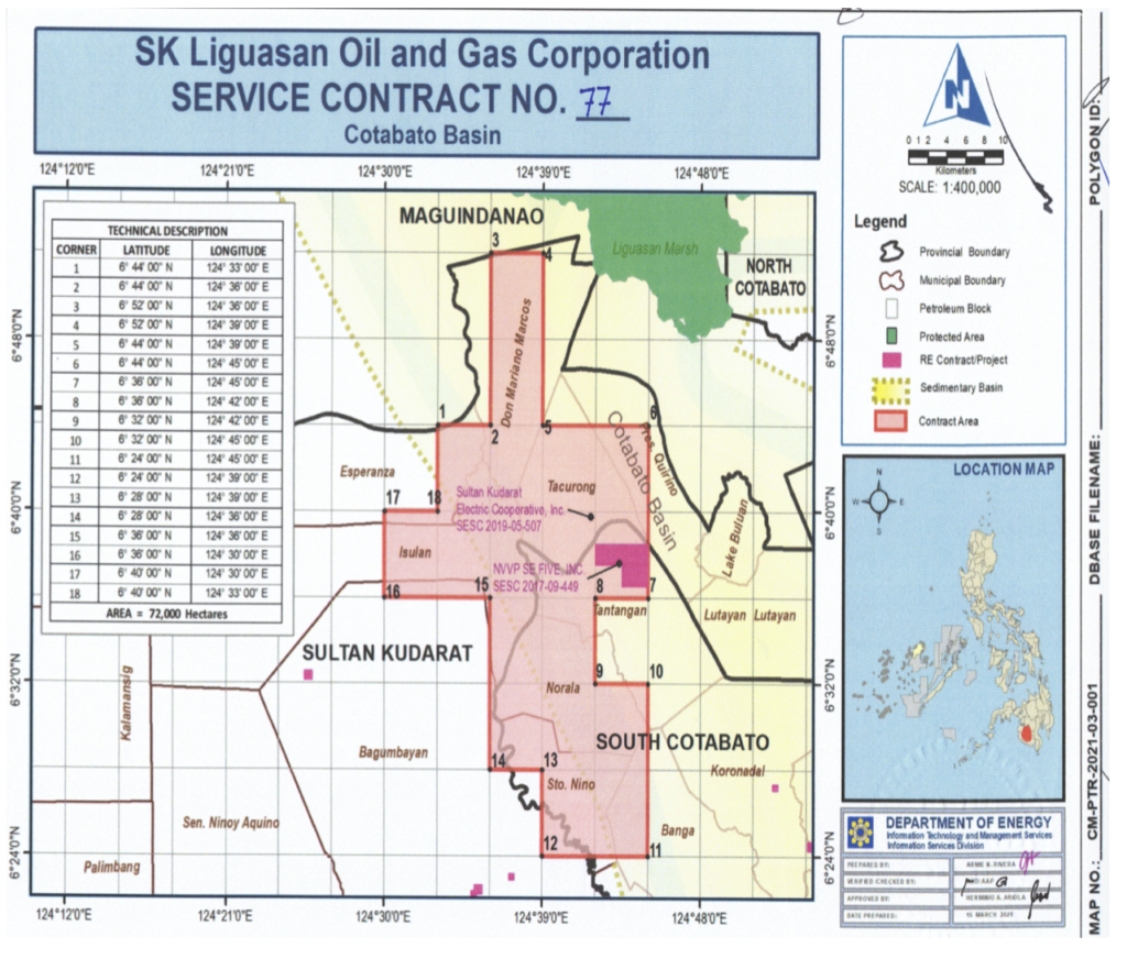
PSC 77 total land area is 72,000 hectares encompassing the provinces of Sultan Kudarat and South Cotabato. It contains the huge natural gas deposit (3.4TCF) in Barangays Bilumen (Gansing 3), Lagao and Tambak in the municipality of Lambayong, Barangay Bambad in the municipality of Isulan (Bambad 2) and Barangay Pedtubo in the municipality of President Quirino. The massive oil reservoir (4.8 BBL) in the Roxas mountain range between the municipalities of Tantangan and Banga, in the province of South Cotabato is also included. SKLOGC is granted a 7-year Work Program for exploration and 25 years contract extendable to another 25 years if it successfully achieves its drilling objectives PSC 77 area[1].
Liguasan Marsh – The Next Frontier
In 2000 to 2004, permission was granted to 3 exploration teams from the USA, Canada and Australia, heavily escorted by troops of the Philippine Army (6ID) to inspect Liguasan Marsh. All of these teams reported back that they found presence of natural gas and oil seepage. However, these teams never returned to Liguasan as the area because of security issues was considered “No Man’s Land” by the DOE. This could be the main reason why there is no available significant seismic and geological data on Liguasan Marsh as oil and gas companies that wanted to conduct seismic survey in Liguasan were prevented.
At 70% recoverable, the natural gas quantity of 3.4 TCF could power 3 – 5 power plants that could generate 3,400 MW while the 4.8 BBL crude oil could feed an oil refinery which has a capacity of 400,000 barrels per day that could last for 33 years. This oil and gas production is intended for the Philippine domestic market.

Because Liguasan Marsh is never seismically surveyed there is no significant data on its oil and gas potential. However, several speculators estimated that Liguasan Marsh potential natural gas deposit is within a 300 square kilometer radius (282,744 hectares) with a value equivalent to 583 billion barrels ($1T). Aside from oil and gas, Liguasan could be a major source of rice (around 120,000 hectares could be planted with palay), vegetables and many varieties of fresh fish.
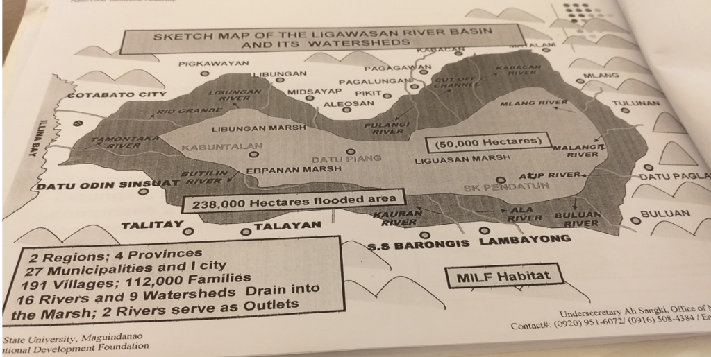
Liguasan is a marshland that has a land area of 280,000 hectares. It encompasses 2 regions (BARMM and Region 12), 4 provinces (North and South Cotabato, Sultan Kudarat and Maguindanao), 27 municipalities and 1 city (Cotabato City). There are 112,000 families from 191 villages living in Liguasan. There are 16 rivers and 9 watersheds that drain into Liguasan and 2 big rivers (Rio Grande de Mindanao and Tamentaka) that empty the water into Illana Bay and Celebes Sea. Three to four months a year, because of the rainy season the villages around Liguasan are heavily flooded.
Given a chance, it is the intention of SKLOGC to conduct a massive aerial gravity and seismic survey in Liguasan Marsh in the near future. The seismic survey would take one year (6 months for survey and another 6 months for seismic interpretation).
https://en.wikipedia.org/wiki/Liguasan_Marsh
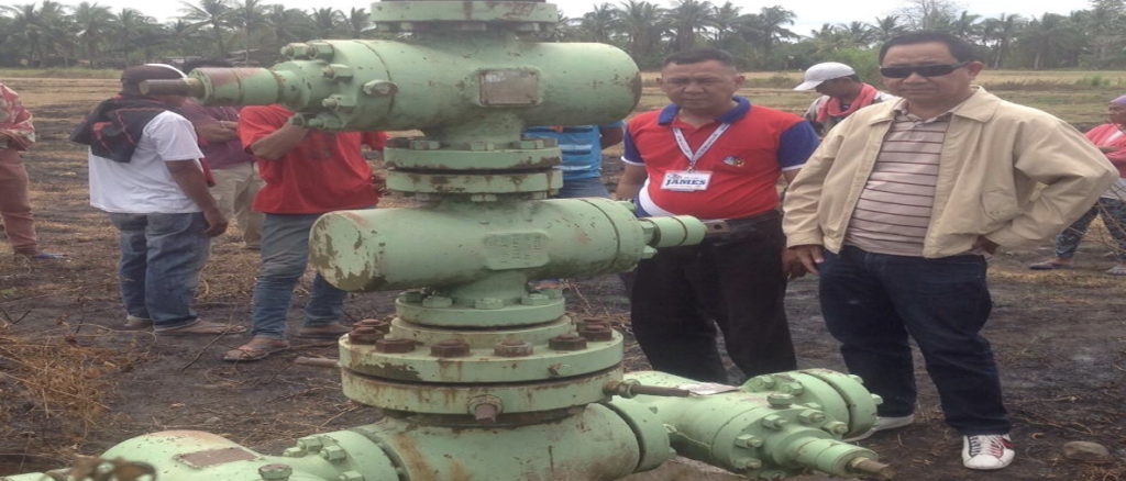
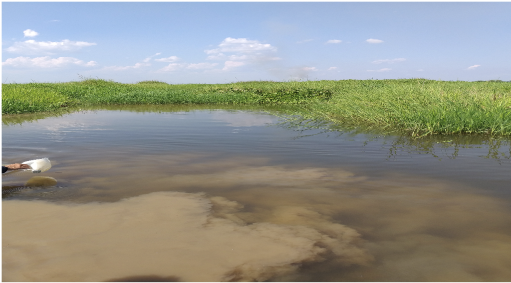
The picture below was personally taken by the author on 31 January 2020 when he surveyed Liguasan Marsh, not escorted by the Philippine army but by MILF elements. An oil sample from the oil seepage was submitted to Energy Secretary Alfonso Cusi on 04 February 2020, who subsequently opened the Cotabato Basin back to oil and gas exploration.
The Future of the Cotabato Basin
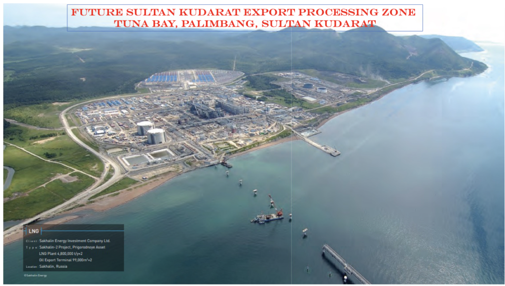
Incoming generations would recognize the importance of the Cotabato Basin to the economy of the country. Should SKLOGC as PSC 77 contractor successfully extract and produce the 3.4 TCF natural gas in Sultan Kudarat sites and the 4.8 BBL of crude oil in the Roxas Mountain Range of South Cotabato, the contribution of the Cotabato Basin to the Philippine economy would be tremendous. Since a 3.4 TCF of natural gas source could supply 3-5 power plants to generate 3,400 MW of cheap, clean and available electricity, it is just logical that an Export Processing Zone Area (EPZA) be established in Sultan Kudarat.
Tuna Bay, a deep anchorage area in the municipality of Palimbang, Sultan Kudarat alongside the coastline of Celebes Sea offers the best site for an EPZA. This Bay was chosen because 200 meters from the shoreline, the water depth is already measured at 20 fathoms (120 feet), where a Very Large Crude Carrier (VLCC) having a 93-feet draft could dock and load refined petroleum products. Once the Palimbang EPZA is completed within 5 years, Tuna Bay would become a new maritime route since Celebes Sea is considered a Sealine of Communication (SLOC) connecting to the right maritime nations of Malaysia, Indonesia, Brunei and Singapore; to down under state of Australia and New Zealand; and turning left to the Pacific Ocean coastal nations of the USA, Canada, Russia, Japan, China and the rest of Southeast Asian countries.
Should the entire oil and gas deposit in the Cotabato Basin as defined in the PSC 77 (area 09) and Liguasan Marsh (Area 10) would be extracted, the Philippines would become an automatic member of the Oil Producing Exporting Countries (OPEC) of the world. The electricity rate in the Philippines to include prices of fuel products would be at a level found in OPEC nations. This could be a far flung consequence when oil seepage first appeared in Dulawan (local dialect means gold or black gold for oil) more than a century ago which the living generation in the Cotabato Basin and the rest of the Philippine Archipelago would enjoy for the next century.
The drilling operation of Anglo-Maremco with its American crew was unsuccessful. The reasons behind were as follows: (1) the Cotabato Basin is categorized a high-pressure zone which the technology in the 1960’s could not address; and (2) the rated drill rig capacity is limited to 6,000 feet which latest prognosis study indicates the rig must breach the minimum depth of 8,250 feet. While the effort of Anglo-Maremco was unsuccessful because of rig difficulty, presence of oil and gas especially in the Gansing sites which flared out to a height of 68 feet for several days cannot be denied any longer. In his Final Report of Gansing 1 & 2 and Bambad 1 wells, which the Chief Geologist Ignacio S Antonio published on 25 November 1964 concluded that the Gansing prospect remains a viable business venture. The oil and gas deposit in Gansing settles in a 5,000-hectare reservoir (one-fourth of the land area of Lambayong, Sultan Kudarat) at a penetrable depth of 8,250 feet and volumetric thickness of 600 meters. Shown below is the Drilling Progress Chart of Anglo-Maremco reported on 24 June 1962. The irregular lines according to our Chief Drill Engineer indicated an intense rig difficulty encountered by the drillers due to the high – pressure zone characteristics of the Gansing site.
The first exploration well Gansing -1 was drilled in 1962 to test a seismically defined anticline. The well however did not reach its target depth due to over-pressuring at Early Pliocene clastic level. Several wells with various targets from sandstone to limestone (carbonate) reservoirs were drilled all over the basin.
The first 240-line kilometers of 2D single fold seismic data was acquired by Maremco in 1962, which was the basis for the assessment and the drilling of Gansing 1 & 2 structural interpretation. Another 381-line kilometers of 6-12 Fold 2D seismic survey was acquired by Fil-Am Resources, which was the basis for the other wells Roxas well, Bambad and Pedtobo.
Speak To our team